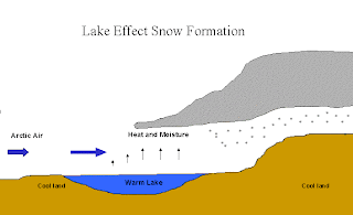
Chicago has always been known for its crazy wind and cold winters. Lake effect snow can cause some of the worst snow storms, leaving the city with up to 35 inches of snow each year. Here is why:
Throughout the winter Chicago falls under a Continental polar (cP) air mass, meaning it is very cold and dry. While the atmosphere remains stable, meaning it needs a force to move it, a high pressure exists.
Having High air pressure allows for the atmosphere to absorb parts of the surface, such as water evaporation. As the pressure moves from High to Low, the high speed winds that move the weather front across Lake Michigan combined with the moisture from the lake create lake effect snow. The steep pressure gradient across the Great Lakes region causes stronger winds because of the faster transition from High to Low.
As the weather front moves across Lake Michigan the warm water evaporates into the clouds increasing the amount of water vapor in the clouds. By the time the front reaches land, with a cooler surface, there is enough moisture in each cloud to create large amounts of snowfall.
Snowfall can leave the crowded city in a state of winter wonderland
Lake effect snow can cover the entire Great Lake region as shown in the picture above. Chicago sits right on Like Michigan making it susceptible to some of the worst snow storms, and giving it the nickname “The Windy City”
Images taken from Bing and from Professor Allen's daily lectures


