Tuesday, May 3, 2011

The Reversing of a River

One of the largest cities in the United States also happens to be a part of a fluvial landscape. The Chicago River that runs through the middle of the city has played a vital role in the building and expansion of the city itself.
The city built itself with access to the river. Today some of the largest buildings meander with the river.

The Chicago River is a perennial river; meaning it flows year round, however it does not flow at a very fast rate which does not allow heavy sediment to move very quickly. As I stated, Chicago was built around this river, from streets to buildings the city has transformed itself, along with the river. Concrete banks follow the river to support the structures; however like we discussed throughout class, the river will eventually begin to erode the concrete and change the structure of the river itself. This can lead to the collapsing of the concrete banks, causing a problem for the buildings, bridges, and streets build so close to the river.
  Chicago will have to deal with the breaking down and erosion of the rivers concrete banks in order to protect the structures and roads that follow the river.

In my second blog I discussed how the major flooding of the Chicago River emptied unsanitary waste, causing the closure of Lake Michigan and the river. The problem of unsanitary waste flowing through the river has caused Chicago to restructure the river over time. Throughout the 1800’s and early 1900’s the river was used to rid the city of sewage, pouring pollution directly into Lake Michigan. Many Chicago residents became ill and died because of the unsanitary river. This led Chicago to reverse the flow of the river through the creation of the “Sanitary and Ship Canal,” in 1900. The canal used locks to reverse the flow of the river to keep unsanitary water out of Lake Michigan; at a higher velocity the river began to pump fresh water throughout the city.  

The unsanitary pollution could be seen as a dissolved load, meaning the river carried the chemicals throughout the city spreading disease.
 Without the use of the river, Chicago would not be what it is today. This fluvial landscape was left as a result of the melting of the Laurentide ice cap.

The melting of the glacial landform has transformed into one of the largest cities in the world!
-Jason Bolton
Sources:
Pictures taken from Bing Images

Thursday, April 7, 2011

Winter Wonderland with Wind

Chicago has always been known for its crazy wind and cold winters. Lake effect snow can cause some of the worst snow storms, leaving the city with up to 35 inches of snow each year. Here is why:


Throughout the winter Chicago falls under a Continental polar (cP) air mass, meaning it is very cold and dry. While the atmosphere remains stable, meaning it needs a force to move it, a high pressure exists.

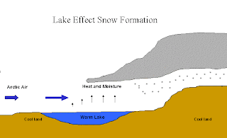
Having High air pressure allows for the atmosphere to absorb parts of the surface, such as water evaporation. As the pressure moves from High to Low, the high speed winds that move the weather front across Lake Michigan combined with the moisture from the lake create lake effect snow. The steep pressure gradient across the Great Lakes region causes stronger winds because of the faster transition from High to Low.

As the weather front moves across Lake Michigan the warm water evaporates into the clouds increasing the amount of water vapor in the clouds. By the time the front reaches land, with a cooler surface, there is enough moisture in each cloud to create large amounts of snowfall.

Snowfall can leave the crowded city in a state of winter wonderland


Lake effect snow can cover the entire Great Lake region as shown in the picture above. Chicago sits right on Like Michigan making it susceptible to some of the worst snow storms, and giving it the nickname “The Windy City”

Images taken from Bing and from Professor Allen's daily lectures

Thursday, March 3, 2011

2 1/2 Million people, 7 inches of rain, one river...on big problem!

While there is no sign a landslide or rock fall will happen in Chicago anytime soon, one thing the city has to be worried about is flooding. According to the Weather Channel, Chicago sees an average of 3.68 in of precipitation during July. On July 14th, 2010, when nearly 7 inches of rain fell the city witnessed its most recent flood, causing the Chicago River to overflow and put 12 Illinois Counties on Disaster Alert
Chicago Residents obviously have not listened to Professor Allen. "Don't be a macho when you drive!"

The Chicago Tribune estimated the total damage of the flood to be over $12 Million. The flood was caused by high drainage density and because the massive city is full of concrete structures and roads, low permeability because there was nowhere for the water to go.  Flooding roads like the picture above as well as basements and buildings, the water caused a great deal of damage for residents.
A system of locks was built in the early 1900’s in order to prevent unsanitary water to flow into Lake Michigan. However the massive flooding in July forced the locks to be opened in order to drain the water from the city. This created a problem however, not only were Chicago residents affected by the flood, they were now affected by the unsanitary water in the lake.
Even if residents were not affected by the floods, they were now affected as a result. The Lake Michigan beachfront was closed because of the bacteria and pollutants in the rivers. Polluted waters were the reason for building the locks; however a high density and low permeability made it impossible to keep the locks closed.
The map above shows the Chicago River as well as surrounding rivers and streams. While the Chicago River runs right through the city, there is only a few other rivers than can help drain the river while flooded. The Chicago River is a first order tributary leading into Lake Michigan.


While Chicago may not be known for its geography, the River flowing through out the massive city has proved that intense rain can cause plenty of damage.

Sources:
Additional Sources:

Tuesday, February 15, 2011

The Great Lakes made Chicago

One of the major advantages Chicago has is the Great Lakes. The Great Lakes offered easy transportation of goods in and out of Chicago, turning the city into one of the largest today through transportation of goods from eastern U.S. to the west. Without the formation of the Great Lakes roughly 10,000 years ago, Chicago would not be the city it is today.

The lakes rest upon an area known as the Great Lakes Tectonic Zone and were formed by the extension of tectonic plates over 1 billion years ago, creating the Midcontinent Rift. Another part of the lakes geography is known as the St. Lawrence rift, an active seismic zone which created the area for the lower lakes 500 million years ago. While the zone is active, it is not known for very many earthquakes which could cripple a city like Chicago.

Having being formed during the last ice age, the lakes became filled with water as the Laurentide ice sheet melted. Basins that were created by the ice glaciers became filled with water and now known as the Great Lakes. While the formation of the lakes occurred over 10,000 years ago, they were vital to the creation and industrialization of Chicago to one of the largest cities in the world today.

Images from Bing
Sources: http://en.wikipedia.org/wiki/Great_Lakes

Wednesday, January 26, 2011

Welcome to my blog! My name is Jason Bolton. I am currently a junior majoring in Marketing. I have always been interested in traveling and seeing all the different images our world has.

The location I chose is Chicago, Illinois. Chicago is also known as the "Windy City," however I do not know the full explanation for this, I plan on learning through out this experience. Located next to Lake Michigan, Chicago was built upon its easy access from the Chicago River and Lake Michigan. There are two rivers, the Chicago and the Calumet river that flow through the city itself. While Chicago is one of the largest cities in the world, I believe there is many geographical parts that can be seen.

Chicago has been one of my favorite places to travel to. I fell in love with the city the very first time I traveled there. From the rivers downtown to the Navy Pier, as well as Lake Michigan all intertwined with the massive skyscrapers, it is an awesome place!